17 Comments

Recently the Washington Boulevard Trail project has come under criticism from the Urban Forestry Commission and the Penrose Neighborhood Association due to the number of trees that would be impacted by it's construction. While the potential loss of trees is unfortunate, the myriad environmental, health and mobility benefits of the trail seem to have been lost in the shuffle.

Project Overview

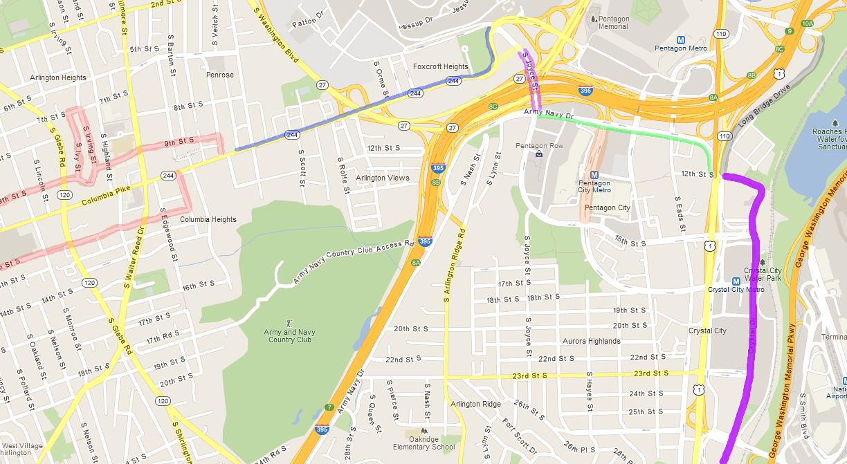
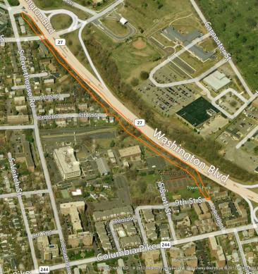
The Washington Boulevard trail project would construct a new bike and pedestrian trail along the west side of Washington Boulevard between Route 50 and South Rolfe Street just shy of Columbia Pike by way of Towers Park. Phase I of the trail was completed in 2009 as part of a water main project and runs from Route 50 to the South Courthouse Rd exit of Washington Blvd. Phase II will complete the trail and is currently at 90% design completion (the approximate area is outlined in yellow on the map). The trail is identified as high-priority project in the Arlington Master Transportation Plan and would link the Arlington Boulevard Trail to planned bikeways coming to the east end of Columbia Pike and to a long-term project that would provide a new connection under I-395 via the Army Navy Country Club called the "Hoffman-Boston Connector".

Tree Removal

Because of the hilly nature of the land along Washington Blvd, approximately 2.7 acres of currently vegetated land would need to be disturbed during the construction process. This results in 297 trees that could potentially be impacted, of those 186 (of which 6 are dead) would have to be removed, while the project would try to preserve and protect the remaining 111. Of those that would need to be removed only 17 are "large" (20" diameter+) while over half (91) are "small" (under 10" in diameter).

Clearly, this is a LOT of trees and not an ideal situation, but what do we get in exchange?

New Trees

Any trees removed would be replaced under the County's Tree Removal formula - the current calculation would result in the planting of 250 new trees. If space allows, they would be planted within half a mile of the project site. While the trees planted would be small, they would all be native species (unlike many of those being removed) and would eventually, after decades of growth, result in a fuller tree canopy and improved air quality in the area. While the County's trail guidelines recommend not planting new trees within 10' of the trail (so as to avoid tree roots destroying the trail over time) much of the area being dug up is only being disturbed in order to regrade it - those areas are prime locations for replanting and will eventually help shade the trail. In addition, Towers Park which the trail runs through is fairly bare and would benefit from the planting of many new trees (at least in my opinion).

Increased Cycling

Building new bicycle infrastructure is vital to encouraging additional people to bike, especially off-street infrastructure like trails. There are many folks who are interested in biking but are intimated by the idea of sharing the road with cars. Trails and other off-street routes function like training wheels allowing new cyclists to come up to speed with urban cycling in a slow, controlled way. The Washington Boulevard trail would be the only off-street route linking the Columbia Pike corridor with points north other than the W&OD trail in the western portion of the County.

Public Health

With increased cycling comes public health benefits. Cycling, whether as recreation or as transportation is excellent exercise and helps combat the obesity epidemic sweeping our nation.

Decreased Carbon Footprint

With increased cycling comes environmental benefits. Some trips that would previously have been taken by car will instead be taken by bicycle resulting in decreased emissions. Recreational trips may displace other forms of recreation like watching TV or going to the movies which require electricity providing further emissions benefits.

Increased Park Safety

One request that frequently comes up in Neighborhood Conservation plans is for increased police presence in our parks. Many are concerned about vandalism and crime in these often out-of-the-way areas. Putting the Washington Boulevard trail through part of Towers Park would provide many additional "eyes on the park" throughout the day as cyclists and pedestrians pass through helping deter crime and vandalism in the park.

A New Generation of Environmentalist

Finally, the best way to ensure that our parks and natural areas are preserved in the future is by instilling a love and passion for nature in our children. By increasing access to our parks and natural areas, and by encouraging outdoor activities like cycling and jogging, trails help bring this love and passion to people, especially young people. Those spending all day inside staring at the TV are much less likely to care about trees and streams as they age.

The Washington Blvd trail would be especially useful in this regard as Towers Park is relatively cut-off from the rest of the neighborhood, surrounded on 3 sides by Washington Blvd and Department of Defense property. To access it from the majority of Penrose, one must walk down South Courthouse Road to Columbia Pike, walk East down the Pike and then double back up to the park on Rolfe or Scott Street. The trail would make for a much more direct and pleasant path for residents using the planned trail access at 6th Street.

Alternatives? Improvements?

The Penrose Association's letter is careful to oppose the trail project "as currently designed". The Urban Forestry Commission, however, go so far as to recommend that the trail be completely scrapped as their is a "safe alternative for bicycle and multiuse...available along South Courthouse Road" which is absurd to anyone who has attempted to bike in the area. South Courthouse is a relatively busy, extremely hilly street with significant speeding problems. Biking on it is fairly common, but only by cyclists who are already quite comfortable with on-street cycling. South Courthouse Road doesn't actually get you to Towers Park, however, to do that you have to traverse four blocks of Columbia Pike. Cycling on-street on Columbia Pike is something done only by the bravest and most confident cyclists, and the alternative is narrow sub-standard crumbling sidewalks. While improvements are coming to the portion of Columbia Pike, and some improvements are coming to South Courthouse Road, it will never be welcoming to beginning cyclists like an off-street trail would be.

Other suggestions I've heard include narrowing the trail, narrowing the buffer around the trail and making portions of the trail on a raised "boardwalk" to avoid damaging significant trees. We have some existing boardwalk section of trail in Northern Virginia. In my experience they are all dangerously slippery at least a portion of the time - many are dangerously slippery ALL the time. Narrower trails present obvious safety concerns. Narrowing the buffer on either side of the trail is something that seems like a reasonable place to further compromise as long as it doesn't adversely affect sight-lines on the trail.

Building a project like the Washington Boulevard trail is a balancing act. The route that is best from a transportation perspective is likely not the best from a tree-preservation perspective; neither is probably the most cost effective route. County Staff weigh these and many more factors when planning these projects. To not build the project at all or to make further compromises that impede the trail's effectiveness as a transportation corridor would lose us all of the benefits outlined above. If you feel as I do that those benefits outweigh the loss of trees, please join me in signing the online petition below:

6 Comments
It's about 2 miles from Columbia Pike's Town Center (the commercial zone centered around the intersection with Walter Reed Dr) to the Pentagon City Metro, a trip that should only take about 10 minutes by bicycle. Cyclists on this route are a rare sight, however, due to traffic conditions and substandard infrastructure along the way. Improvements are coming over the next few years; they won't bring cycling nirvana, and they won't come overnight, but overall they represent a significant improvement in the cycling experience between Columbia Pike, Pentagon City and Crystal City.

Current Conditions
Cycling on-street on Columbia Pike is quite harrowing for any but the most confident cyclists. Traffic volumes are heavy; when not stopped at a light, traffic often moves quickly, especially once you get East of South Courthouse Rd. Cyclists traveling during morning rush have the added joy of needing to ride in the left lane for a while due the the right lane of Columbia Pike becoming a turn lane during morning rush as it approaches the Washington Blvd bridge. Once you're past Washington Blvd traffic volumes thin out a bit, but you're heading uphill to the Navy Annex and what traffic is coming is likely paying little head to the 25 mph speed limit. Once you crest the hill, the downhill toward Joyce makes for a pleasant descent, helping you keep up with oncoming traffic. Joyce Street heading under I-395 is, if anything, worse than most of Columbia Pike - wide lanes and a freeway like appearance cause cars to exceed the already inexplicably high 35 mph speed limit. To make things worse, the sidewalk isn't even a reasonable alternative to any of this. The sidewalks along most of Columbia Pike and along Joyce are narrow, riddled with obstacles, bumpy and frequently chock full of folks waiting for the bus. Riding in the neighborhoods on either side of the Pike so as to avoid biking the Pike is possible but challenging (bring a map!) - street connectivity is spotty and no one road will allow you a signalized crossing of the various North/South arterials.

Once you've made it to the East side of 395 those heading for the Metro now have the option of a round-about route with bike facilities (Joyce to Hayes) or contending with a 6 lane arterial (Army Navy Dr). Those heading for Long Bridge Park again have a round-about option (Joyce to Hayes to 12th across the bike/ped path continuing on 12th to Long Bridge Dr) or contending with Army Navy Dr. Were it not for the one-way portion of 12th/Crystal Dr cyclists could avoid Long Bridge Dr altogether and directly access the Long Brideg Dr esplanade from the corner of 12th & Crystal Dr. Those heading to southern Crystal City or Potomac Yard will find themselves stymied by various one-way portions of Crystal Dr and a lack of decent east/west access roads to get to it in the first place - 15th St, 18th St, 23rd St - none of these have bike facilities. If you're just passing through you'll probably want to stick to Eads St though it's bike lanes could use some TLC.

What's Coming:
The Columbia Pike Bike Boulevards Project

This project attempts to make 9th St and 12th St the go-to option for cycling along the commercial core of the Columbia Pike corridor. The project will include sharrows all along 9th and 12th St, various curb extensions to narrow the travel way which should help curb speeding, swapping some 2-way stops so that the cross street stops rather than 9th or 12th St, various intersection reconfigurations and the installation of HAWK signals at unsignalized intersections with major arterials (Glebe, Walter Reed, George Mason Dr). The initial plans have been updated based on resident feedback and to coordinate with other projects. The reconfiguration of 9th St and Walter Reed has been moved into the Walter Reed Drive Decal Fee project that is currently in-design. 9th Street will not be converted to two-way traffic until the County can come up with a solution to the neighborhood's concerns about cut-through traffic. In the interim, Eastbound bike traffic will be routed up Ivy, across 7th St and back down Irving; in reality, given the low traffic volumes there, I expect to see rampant salmoning as the preferred alternative for most cyclists over a 5 block detour. Improvements to the trail in Doctor's Run Park have been moved to two separate projects: The lower trail from the school trail to George Mason Dr. will be improved as part of a Neighborhood Conservation project. The upper trail from the school trail to S. Quincy St. has numerous large trees and drainage issues that also require it to be addressed in a separate project. As far as I know, no timeline or funding source has been identified for the second project.

The easy changes in this project (signage & paint) are expected to being late this Summer; curb extensions, medians, HAWK signals, and sidewalk realignments will all require a field survey. The survey is expected to occur late this Summer as well, with design work resuming on these elements once the survey is complete; The HAWK signals will require VDOT review which will take additional time as well.

The Columbia Pike Multimodal Project

This project will essentially completely reconstruct Columbia Pike from the Fairfax line to Joyce St. It will bring a mostly standard lane configuration to the Pike - 11' outside lane, 10' inside lane and either a left turn lane or median in the center. From a cyclist perspective, the interesting pieces are the lack of bike lanes (due to right-of-way constraints and the strong possibility of streetcar tracks coming the pike), the potential for narrower lanes reducing traffic speeds and the addition of two segments of 10' wide sidepath - one on the East end of the Pike and one on the West. On the west end, a 10' sidepath on the North side of the Pike will connect Jefferson St with the Four Mile Run Bridge. On the East end, a 10' sidepath on the North side of the Pike will connect Vietch Street down to Joyce St.

Detail-oriented readers may have just realized that the 10' sidepath stops exactly one block short of the 9th St bicycle boulevard. Staff have said "Current plans leave a gap between Wayne and Veitch, where the church property and retaining wall make widening the sidewalk very difficult" which I'm not sure I buy - the current plans actually show a 6' sidewalk and 5' landscaping strip on that block. It would seem the solution is as simple as removing that one block of landscaping strip; while I would mourn the loss of those trees, it would seem on balance to be worth the loss in order to avoid the interruption in bike facilities. There are many more street trees called for in the reconstructed Columbia Pike than are there now so the project as a whole would be a net gain in tree canopy. I have queried staff on this issue but haven't yet heard back on whether there is some other unknown issue that makes the solution more complicated than removing a block of landscape strip. UPDATE FROM STAFF (6/15/12): "At this point, we can officially state that it looks feasible to extend the shared facility (wider sidewalk) to S. Wayne St. but we'll need to verify this as we move forward in the planning process."

The plans are at the 50% design stage and are now being revised to address both VDOT and County staff comments and will then be resubmitted to VDOT. The project will then proceed to final design. That process should take about another year or so. The County expects to begin construction starting at the Fairfax County line and moving eastward in phases. The first phase (from the Fairfax County line to S. Frederick St.) is expected to begin in Summer or Fall of 2013.

Columbia Pike Realignment

Arlington National Cemetery is expanding; the gas station on Joyce has already been demolished to make way and the Navy Annex and Southgate Road will soon follow. Arlington County is in negotiations to potentially realign the east end of Columbia Pike to have it meet Joyce Street much closer to I-395. This would allow Arlington National Cemetery additional contiguous land and allow Arlington to make many potential upgrades to that area of the Pike. An agreement has not yet been reached but it is hoped that the realignment would nicely match up with the end of the next project on Joyce St.

The Joyce St Sidewalk Project

This project runs along Joyce St as it goes under I-395, from Army Navy Dr to approximately where the old gas station was before it was demolished. Excess travel lane width is being converted into extra room for the sidewalks on both sides of the road. Existing sidewalks are narrow, with numerous intrusions and partial obstructions and are placed close to highway guard rails and moving vehicles. The area also lacks appropriate lighting. The new configuration will retain the two road lanes in each direction that currently exist, but the approximately 5 ft. wide sidewalks will be replaced by 8 ft. wide sidewalks with 4 ft. of buffer zone between it and traffic. Pedestrian scale lighting will also be added into the buffer zone. While County Staff advised, this project is funded and managed by the Federal Highway Administration; the project was recommended in the 14th Street Bridge Environmental Impact Statement. Cyclists who are intimidate by the traffic on Joyce should appreciate the improved sidewalks; the narrowed lanes and less freeway-like atmosphere will hopefully slow traffic for those of us who bike on-street.

Construction started at the beginning of May and is expected to take five months.

The Army Navy Drive Cycletrack

This project will consist of a "road diet" on the existing travel lanes on Army Navy Drive, including removal of the median, to provide room for a two-way dedicated bicycling facility on the south side of the right-of-way, alongside the existing sidewalk. Traffic signalization and driveway apron changes would also be included in the project. While early in the design phase, the initial proposal is that it run from Joyce St to 12th Street providing a critical connection between the Columbia Pike corridor and Pentagon City / Crystal City. In response to my inquiry, County staff described the project as "early in the design phase" and "without a specific timeline" but the County Manager's Proposed (not yet adopted) Capital Improvement Plan has funding for the project in the 2015, 2016 and 2017 fiscal years so I would expect that to at least be a "best guess" at this time.

Long Bridge Drive Reconstruction

Long Bridge Drive (formerly Old Jefferson David Highway) is being reconstructed between 12th Street and Boundary Channel Drive and will include Bike Lanes and smooth, brand new pavement when completed. This project has been held up multiple times by various issues with the underground utilities but is expected to wrap up this Fall.

Crystal Drive Two-way Conversion

This is a three phase project that will eventually convert Crystal Dr from 12th Street down to Potomac Ave to two-way operation. In the areas that are currently 1-way, there will be sharrows in the northbound lanes and a Southbound / Eastbound bike lane. (some portions of Crystal Dr are already two-way and include bike lanes in both directions.

Phase I covers the northernmost block (Crystal Dr / 12th St / Clark St / 18th St) and will begin construction this Summer. Phase II covers Crystal Dr between 23rd and 26th St and will begin construction late this Summer or this Fall. Phase III will cover Crystal Dr between 26th and 27th St and will also cover 27th St itself between Route 1 and Crystal Dr. Phase III is still in the conceptual stage and is without a firm schedule.

The Hayes Street Multimodal Project

Hayes Street by the Pentagon City Metro is already somewhat bike friendly with bike lanes stretch from Army Navy Dr all the way to Eads. Along with many pedestrian improvements, this project will also bring green paint to those bike lanes and will double the amount of bike parking at the Metro (some of which will be covered).

Construction begins this Summer.

Combined Effects

So once all these projects are complete, how do our hypothetical trips change? Biking along the Pike could now be accomplished on either the 9th St or 12th St bike boulevards, low-speed residential street with sharrows and signalization to cross major arterials. Riders could then transition via a single block of sidewalk riding from the 9th St Boulevard to the 10' sidepath on the East end of the Pike. At the end of the sidepath on a realigned Columbia Pike our cyclist could then transition either to the wider sidewalk on Joyce or the narrower travel lanes which have hopefully slowed traffic there. If our cyclist is continuing on to the metro, they can now transition to the Army Navy Dr cycletrack and then make a right onto the green bike lanes on Hayes St to park at the new covered bike parking at the Metro. If they are heading to Long Bridge Park (perhaps to cruise the esplanade) they can take the Army Navy Dr Cycletrack over to 12th Street which now being two way allows them to access the esplanade at the corner of Crystal Dr and 12th or they can turn onto the bike lanes on Long Bridge Drive. If they're heading to Crystal City or Potomac Yards, they can take the Army Navy Dr cycletrack to 12th St, get in the bike lane and continue all the way down to the Potomac Avenue sidepath.

Look for another post in the coming weeks with my thoughts on further improvements that can be made in Columbia Pike Corridor and its connections to Pentagon & Crystal City.

0 Comments
One of my long-time desires for Columbia Pike is finally becoming reality: on a beautiful Summer evening, there will soon be a purveyor of sweet, frozen desserts within walking distance. Menchie's Frozen Yogurt has signed a lease at Penrose Square. I've never heard of Menchie's before, but they appear to be a nation-wide chain, and their caloric content seems comparable if slightly higher than other chains in the area like Red Mango. Menchie's sells their yogurt and toppings by weight, much like the Yogiberry in Pentagon Row. The location is expected to open this Fall.

Thanks to Arlnow for the tip.

3 Comments
Kayak Station - Pentagon MMA
Based on a recently approved change of use permit and freshly minted Facebook page, it appears a Mixed Martial Studio is coming to the Pike. The studio will take over the old Kayak Station space on South Edgewood next to the Rite Aid.

0 Comments
There wasn't a ton of new information at the March 20, 2012 meeting on the Columbia Pike / Washington Blvd Bridge, but there were a couple of items of interest. See my previous post on the subject if you need an overview of the project.

Right-of-way acquisition and construction are both expected to start this Spring. They can happen concurrently because most of the project takes place within existing right-of-way. Construction is expected to wrap-up in Summer of 2015.

The contractor confirmed that when the project is complete you will no longer be able to enter Quinn St from Columbia Pike, only enter.

As a pedestrian on the South side of the Pike, you will have two separate crosswalks, one to cross over Queen St, another to cross over the ramp from Columbia Pike toward Washington Blvd. These crosswalks will be tied to separate phases of the stoplight, but VDOT pointed out that on the 2nd phase (when crossing the ramp) you can now also cross Columbia Pike during this same phase of the light - a movement that is practically impossible given the lack of a stoplight or crosswalk there now.

As far as construction impacts are concerned, they said there will be single lane closures which will be confined to 9am-3:30pm so as to avoid impacting rush hour. Construction will take place between 7am and 5pm. There will be some night work and some weekend work when necessary, and there will be a couple portions of construction (such as when demolishing the existing bridge) where they will need to close Columbia PIke under the bridge completely. When this happens, the work will be done on a weekend and Columbia Pike traffic will be detoured up a temporary ramp to meet up with a temporary traffic signal on Washington Blvd, then back down the existing ramp to the other side of Columbia Pike. Hopefully VDOT will post their powerpoint slides from the meeting so I can update this post with a visual to make it more clear.